The zip codes with the most applications for FEMA assistance following Hurricane Harvey are spread out across Southeast Texas and include areas of Port Arthur, Rockport, Dickinson, and Houston. That’s one of the findings of a new Episcopal Health Foundation (EHF) analysis of more than 880,000 FEMA applications across 41 Texas counties affected by the storm.
EHF’s analysis and online interactive map show the total number of FEMA applications for assistance (including housing, rental, and other types of assistance) for every zip code across the area hit by Harvey. It’s all part of EHF’s on-going effort to help organizations make data-informed decisions about where to invest recovery funds to reach those most in need.
“The zip codes with the most FEMA assistance applications reinforce the fact that Harvey hit not only Houston, but so many different communities across our region,” said Elena Marks, EHF’s president and CEO. “We want to make sure that government and philanthropic recovery efforts use this type of information to make good decisions on where investments can really benefit the people who need the most help.”
The analysis found the 77642 zip code in Port Arthur has 13,654 requests for FEMA assistance. That’s the most of any zip code across the region. It was followed by 77084 in the Addicks/Bear Creek area of western Harris County, 77382 in Rockport, 77539 in Dickinson, and 77901 in Victoria.
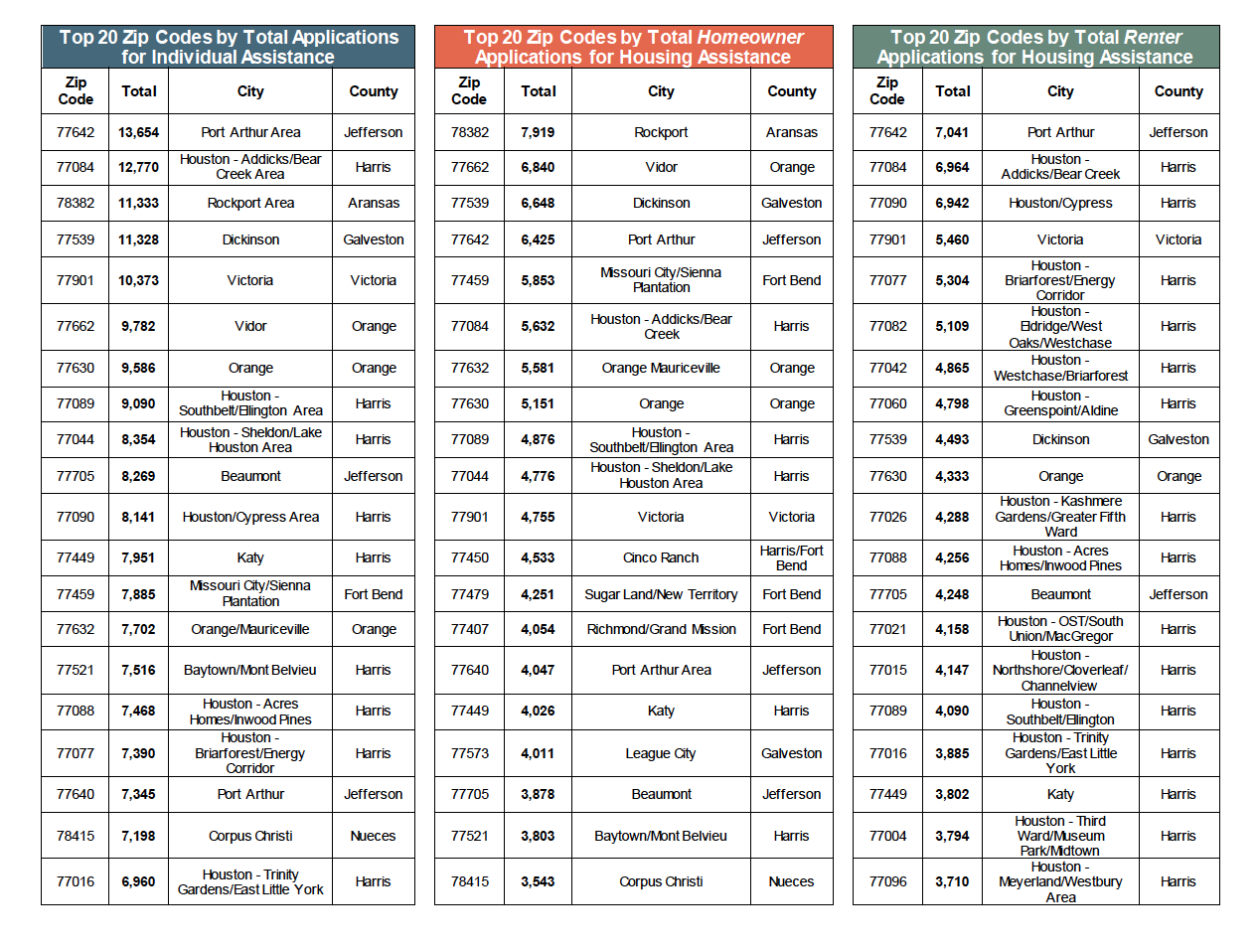
EHF’s analysis also found that 433,571 FEMA applications from homeowners were submitted for housing assistance. In addition, FEMA records show 438,750 applications from renters were also submitted for housing assistance.
EHF analyzed zip-code level data on the total applications submitted to FEMA among all the zip codes located in the 41 counties in Texas that were federally designated for individual disaster-related assistance. The information was included in the “Individual Assistance Open Disaster Statistics” that was last updated by FEMA on November 13.
In addition to the analysis of FEMA assistance requests, EHF developed a Scope of Damage interactive map with layers of information about Harvey-affected counties. The map includes FEMA property damage assessments combined with the Center for Disease Control and Prevention’s social vulnerability index data that explains the resilience of communities when faced by stressors such as natural disasters.
EHF is also partnering with the Kaiser Family Foundation to conduct a randomized, probability-based survey to capture the experiences, challenges and needs of Texans residing in the affected region, especially those in low-income communities. The survey results will be released in early December.
“We’re concerned that the voices of the most vulnerable may not be represented during decisions on how to invest Harvey recovery funds,” Marks said. “We want to highlight the Texans with the greatest needs and fewest resources following the storm.”
###
To schedule an interview with Elena Marks, contact Brian Sasser at bsasser@episcopalhealth.org or 832-795-9404.